

Indian Ridge consists of over 1,400 beautiful acres of diverse mountain property located in rugged and mountainous portion of Southeastern Oklahoma. This incredible property offers views of the surrounding mountains within this valley. The land is quite mountainous and can be steep to rolling with numerous wet weather creeks that traverse the property. This property has some level land along the county road to the south and along the northern ridge. However, there is plenty of aggressive terrain which just adds to the beauty of this land and allows you to view the entire valley below. Wildlife is abundant within this valley due to the great cover and plentiful water sources throughout the property. Larger tracts would be ideal for hunting camps or various recreational opportunities.
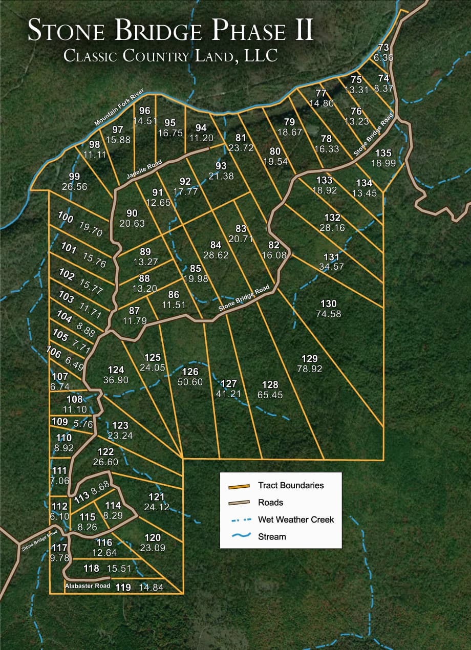
Tract 91 is a beautiful lot with mountainous views and access via an unmaintained dirt road. Tree cover is moderate to heavy with shortleaf pine and numerous other hardwoods indigenous to this area of Central Oklahoma. No power or modern conveniences make this a true off grid plot of mountain land. You, as the new owner, will be able to make it your own by building a permanent residence or a vacation getaway to enjoy many memorable weekend experiences on your land.
Land Specifics
The facts a title company would ask for. Fields render only when we have the data.
- Acreage & Dimensions
- 12.65 acres
- Terrain
- Mountainous terrain within the San Bois Mountains, with a large creek through the middle and wet-weather creeks throughout, including an area with a sheer rock face.
Property Map

Location & Directions
Feel free to visit in person! Some properties have locked gates, so please contact us before making the trip!
Property Documents
FAQs
Location & Utilities
Where is the property located?
What improvements have been made?
What about utilities?
What will the road surface be like?
Financing
What is the minimum down payment amount to purchase and are there closing costs?
If I finance the property, to whom do I make my payments and how will I know I have received proper credit for my payments?
May I use the land while I'm paying for it and when do I receive a deed to my property?
Is there a penalty for paying off my land early?
Does a buyer have to build a house within a certain time frame?
Can I resell my property in the future and make a profit?
Can I make an offer and what kinds of discounts are available?
Why are some properties more expensive than others?
How does the contract-for-deed process work?
Elevation & Weather
What is the average elevation of the property?
What is the average temperature throughout the year?
Zoning & Taxes
What zoning applies to the property, and what are the property taxes for the parcel?
Land Use & Rights
Are mineral rights included?
Is there an hoa or poa?
Can I camp or park an rv on my land?
Are mobile or manufactured homes allowed?
Is hunting allowed?
★ You may also like:
Trophy Ridge is perched on the western edge of the vast Ouachita Mountain Range in Southeastern Oklahoma in Pushmataha County. The property has access via OK-43 on the north which leads into the Indian Nation Turnpike to the west just outside of Daisy, OK for easy driving from both North Texas or Oklahoma. This property is located along the top ridge of Flagpole Mountain which allows for great water views. The land within phase I and II is relatively flat while phase III is quite mountainous and can be steep to rolling with numerous wet weather creeks that traverse the property. Maxwell Creek runs along the southern boundary of this property. A new road system has been established to access all private land tracts. Oak and shortleaf pine are the most dominant trees that cover the landscape of this fully wooded mountain property. Phase I & II does not require a 4WD vehicle to access the property, but Phase III does to access this portion of land.
Stone Bridge lies within the incredible San Bois Mountains just north of Red Oak, Oklahoma, on the Latimer/Haskell County line. This development offers a variety of different terrain to fit your recreational needs, and features mountainous topography that creates a great sanctuary for the deer, turkeys and bear in this area. There is a very large creek through the middle of Stone Bridge with wet weather creeks throughout, and this area receives 50 inches of rainfall annually so water shouldn't be a problem. If you like to hike or rock climb there is even an area with a sheer rock face and this whole area would be great for hiking. All of these tracts would be great for ATV or horseback trail riding, and the surrounding area is just full of recreational possibilities; whether it's exploring Robbers Cave State Park or the winter trout fishing on Fourche Maline River, just west of Wilburton.
