

This charming community of about 2000 sits at the foot of the Greenhorn Valley. There are stores, restaurants, schools etc. here. Colorado City has a community pool, lake, golf course, baseball fields, jogging trails, etc. and so much more. There is some great camping in the area at some very nice RV parks and campgrounds. These pictures are representative of the property and not of the actual property.
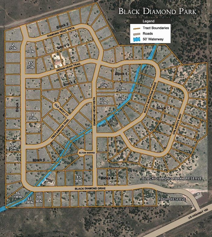
Black Diamond Park, Block 6, Lot 6 is a large .75 acre estate size single-family homesite. This lot offers 147 feet of paved road frontage along Black Diamond Vista. A huge 32,670 sq feet across the entire lot size, with 147 feet width and 240 feet in depth. Underground power and city water are already established to this lot along with high speed cable/internet and phone. This lot faces west with incredible views of the Spanish Peaks to the southwest and the foothills. To the east are views of the Sangre de Cristos in the distance. The lot is mostly native grasses and remains natural with a few juniper and pinion trees. Lot is level to rolling with no slopes more than 20%. If you are looking to invest in an estate homesite in a gated community with all amenities that surround this land. Call us today for easy owner financing! Pay now and build your retirement home later.
Land Specifics
- Acreage & Dimensions
- 0.75 acres
- Road Access
- On U.S. Highway 160, one mile west of Walsenburg.
Property Map

Location & Directions
Feel free to visit in person! Some properties have locked gates, so please contact us before making the trip!
FAQs
Location & Utilities
Where is the property located?
What improvements have been made?
What about utilities?
What will the road surface be like?
Financing
What is the minimum down payment amount to purchase and are there closing costs?
If I finance the property, to whom do I make my payments and how will I know I have received proper credit for my payments?
May I use the land while I'm paying for it and when do I receive a deed to my property?
Is there a penalty for paying off my land early?
Does a buyer have to build a house within a certain time frame?
Can I resell my property in the future and make a profit?
Can I make an offer and what kinds of discounts are available?
Why are some properties more expensive than others?
How does the contract-for-deed process work?
Elevation & Weather
What is the average elevation of the property?
What is the average temperature throughout the year?
Zoning & Taxes
What zoning applies to the property, and what are the property taxes for the parcel?
Land Use & Rights
Are mineral rights included?
Is there an hoa or poa?
Can I camp or park an rv on my land?
Are mobile or manufactured homes allowed?
Is hunting allowed?
★ You may also like:
The San Luis Valley Ranches are nestled high in the Rocky Mountains in the San Luis Valley. Mt. Blanca, the fourth highest peak in Colorado at 14,345 feet, offers stunning views to this subdivision. It is part of the Sangre de Cristo Range. Located centrally around the town of Fort Garland, it is about 25 miles east of Alamosa, 210 miles south of Denver, 175 miles east of Durango and 50 miles west of Interstate 25. It is a large subdivision that covers different parts of the county.
The Sangre de Cristo Ranches were developed in the heart of the Sangre de Cristo Mountain range, with Mt. Blanca at over 14,000 feet, highlighting the scenery. To the west, the San Luis Valley is a fertile High Plains Desert, roughly 7,500 feet above sea level. The landscape of the 44,000 acre Ranches consists of mostly sagebrush and Pinon at the lower elevations, and Aspen and various tall pine varieties above 9,000 ft. The Ranches are located about 5 miles to the south and east of Fort Garland, Colorado.

